My children love studying with the maps. To keep the maps interesting I allow them to choose how they want to study them. Some children are happy working moving from map to map only learning the names of the countries. Some children work with one map and study it further learning the names of the capital cities and flags. Other children decide they would like to look at the land forms in the continents, search for the rivers and lakes, look at which animals live and learn about the culture and people who live on the land. There's such a variety of ways to work with a map, but I always insist that the children learn about the countries first.
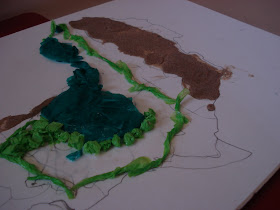
Below is the work of one of my older students. At first she learnt all the names of the country in Africa. She coloured in and labelled a print out map. Next she decided to look at the rivers in the continent, she carefully drew each river in Africa, noting which countries it travels through. She then decided to look at the biomes in Africa. I suggested that she find out about the land and try to construct it using materials that relate to the type of land.
 For the deserts she used sand. She coloured the sand to differentiate between the different deserts in Africa. She used tissue paper for the forests, and layered it to show the layers of a rain forest. She used pieces of finely cut yellow card for the grass land.

The end result is amazing. The learning that took part in the construction of this piece is likely to stay with her forever. After completing this work she decided to do another project on landforms.
It's just beautiful. What an indepth look.
ReplyDeleteWOW....where are you??????
ReplyDelete